
































BANGKOK — 21 August 2026, the Geo-Informatics and Space Technology Development Agency (GISTDA) reported data from its “Check Nam” application, which analyzes satellite imagery and geospatial information to monitor flood risks.
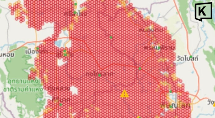
The latest analysis showed a large, interconnected area classified as a very high-risk zone, marked in red, covering floodplain areas in Sukhothai, Phitsanulok and neighboring provinces. The total area currently at risk of flooding exceeds 3,900 square kilometers.
Sukhothai has been widely affected, with large areas classified as high risk. The affected areas are concentrated across the central and lower parts of the province, particularly Sawankhalok, Si Samrong, Mueang Sukhothai and Kong Krailat districts, as well as parts of Si Satchanalai district in the north.
In Phitsanulok, extensive high-risk areas were detected in the central and western parts of the province. The floodwater is connected to the flow from Sukhothai, with major areas of concern including Phrom Phiram, Bang Rakam and Mueang Phitsanulok districts, as well as parts of Wat Bot district.
Nearby areas and neighboring provinces have also recorded both very high-risk zones, marked in red, and low-risk zones, marked in yellow. The risk areas extend across provincial boundaries into parts of Uttaradit, Phichit and Kamphaeng Phet provinces.
GISTDA said the assessment was based on its high-accuracy satellite imagery, which is updated in real time. The data allows authorities to assess the direction and expansion of floodwater accurately, helping relevant agencies and residents plan monitoring and response measures more effectively.
GISTDA advised residents in affected and nearby areas to closely monitor the situation around the clock.